AVEVA and NavVis partner to advance laser scanning and energize the Digital Twin
Posted: May 18, 2022
Building a better tomorrow through technology and innovation is at the heart of AVEVA’s mission, and our partnerships are the lifeblood that makes that mission work. Often, industrial progress is hard-fought and hard-won, but together, we get it done.
AVEVA is excited to announce its new partnership with NavVis, an innovator in mobile mapping and reality capture. Together, AVEVA and NavVis provide users with the technology to access reliable as-built 3D point cloud data and panoramic images.
A digital twin is only as good as the data that composes it. Without solid data, a digital twin will always fall short of your expectations. AVEVA™ Point Cloud Manager manages massive amounts of 3D point cloud data to create an accessible, detailed, and secure digital twin. It can process huge, meticulous data sets with engineering-grade accuracy, ensuring that physical and digital project representations perfectly align. This allows you to make trustworthy, informed decisions, reduce project rework, and improve safety on critical assets.
The NavVis VLX is a wearable mobile mapping system that enables high-quality capture of complex buildings at unprecedented speed and scale – up to 10 times faster than a traditional laser scanner and with comparable accuracy.
“We are very excited to welcome NavVis as our partner in providing the digital twin. We see NavVis’s wearable scanning hardware as a disruptive step forward in the laser scanning marketplace. Together, AVEVA Point Cloud Manager and NavVis wearable scanning technology represent a very rapid way of creating and updating the digital twin.”
- Andy Davidson, Product Manager for AVEVA™ Point Cloud Manager
Once the NavVis VLX captures data, that data is then processed to deliver high-quality data in e57 formats (a vendor-neutral file format for point cloud storage) that contain both 3D point cloud data and panoramic images, without creating additional work for the user. This information is imported into AVEVA Point Cloud Manager, where users can take measurements of the data, link with CAD systems, and publish the dataset for integration with the wider Digital Twin.
“It is a pleasure and privilege to work with AVEVA on advancing the future of digital twins, especially in complex industrial environments. AVEVA is at the forefront of building end-to-end digital twins for such environments that combine reality capture data, complex CAD engineering models, and other critical data. We look forward to enhancing AVEVA digital twins with our very fast and accurate NavVis VLX devices and high-quality e57 data, processed and prepared in NavVis IVION.”
- Ignacio Pérez Hallerbach, VP and Global Head of Partners & Platform, NavVis
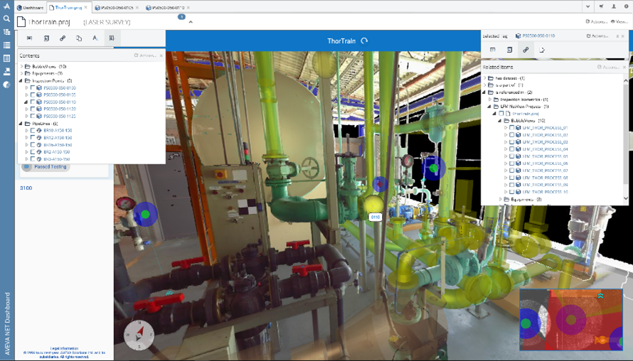
Coupled with NavVis’s hardware capabilities, AVEVA Point Cloud Manager enables users to easily and instantly visualize and access reliable as-built laser point cloud data. Together, these powerful technologies empower multi-discipline, geographically disparate teams to collaborate on the same data at the same time with interactive project reviews. As a result, you can dramatically cut the time and cost on-site survey and inspection require and instead maximize office-based time and resources.

Related blog posts
Stay in the know: Keep up to date on the latest happenings around the industry